|
|
|
|
PLEASE NOTE: The Reality TV World Message Boards are filled with desperate
attention-seekers pretending to be one big happy PG/PG13-rated family. Don't
be fooled. Trying to get everyone to agree with you is like herding cats,
but intolerance for other viewpoints is NOT welcome and respect for other
posters IS required at all times. Jump in and play, and you'll soon find out
how easy it is to fit in, but save your drama for your mama. All members are
encouraged to read the
complete guidelines.
As entertainment critic Roger
Ebert once said, "If you disagree with something I write, tell me so, argue
with me, correct me--but don't tell me to shut up. That's not the American way."
|
|
|
"Nuku Hiva Map thread"
Outfrontgirl 6830 desperate attention whore postings
DAW Level: "Playboy Centerfold"
|
10-15-01, 05:10 AM (EST)
 
  |
|
"Nuku Hiva Map thread" |
LAST EDITED ON 10-15-01 AT 05:47 AM (EST)LAST EDITED ON 10-15-01 AT 05:44 AM (EST) I started a new thread for maps of N.H. and pics of the 4 valleys they plan to use, per the Tahitipresse article I copied into my Nuku Hiva location news thread. 1)Hakaui (spectacular waterfall, more than 1000 feet high)
2)Hakatea (wild pigs roam there)
3)Haeotupa (a labyrinth)
4) Aakapa (no one lives there because of biting flies and mosquitos. I haven't found pics of all of them yet. Hint, hint.
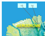
1) Map showing Aakapa coastal village (Valley#4) on north coast and Hakaui on south.
The freighter that serves as transport to the island stops there, and a road is supposedly under construction connecting it to the island's tiny airstrip in the northwest. 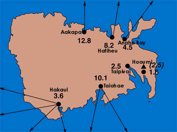
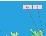
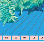
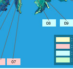
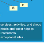
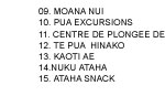
http://www.usc.edu/dept/tsunamis/1946/nuku_hiva/ This link for the above map has more photos, including one of the bay at Hakaui and possibly the waterfall pool (not sure). 2) A large topographical map of the island that I couldn't copy here because it's made of numerous segments. Shows the port and tourist accommodations to the south. The first three valleys are on the unmarked west of the island. Scroll down to the bottom of the page as you won't see the map at first. http://www.tahiti1.com/tourist-map/nukuhiva-en.htm 3) Famous waterfall of Hakaui (valley #1) on south coast.
 HAKAUI Valley is 15 km. (9 miles) from Taiohae on the southern coast. Hike inland to bathe in the refreshing pool of the 350 m. (1,148 ft.) high AHUII waterfall, one of the world's highest cascades. More pics to come I hope.

|
|
|
Top |
| |
Outfrontgirl 6830 desperate attention whore postings
DAW Level: "Playboy Centerfold"
|
10-15-01, 06:06 AM (EST)
|
|
1. "RE: Nuku Hiva Map thread" |
LAST EDITED ON 10-15-01 AT 06:15 AM (EST)Hakatea, also known as Daniel's Bay. Falls are the third highest in the world but apparently just a trickle, some of the time anyway. 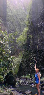
Descriptions by two small sailing groups: 1)"Daniel’s Bay (Ansa Hakatea on the charts) is one of the two inlets in Baie Taioa and is famous because of the hospitality shown to sailors by Daniel and his wife over the past fifty years. Due to age and ill health they no longer provide meals. When we visited his wife had a very very bad leg infection which coloured the leg black and was badly swollen. We gave her antibiotics, which was very much appreciated and in return were given an abundance of pamplemousse a large and very nice grapefruit like fruit. They also claim to have the best drinking water on the island and supply it willing. Huge sheer cliffs surround the bay, which after heavy rain produces lots of waterfalls. A very short dinghy ride round the small rocky headland to the west, still within the bay, and by continuing along the rocks on your starboard side you can enter the river which takes you to the village of Hakaui, there are no facilities or provisions here. The river entrance is not for the faint hearted and neither is landing on the beach which is even more froth with danger. Once ashore the 21/2-hour walk through the valley, passing many ancient sites and tikis, to Vaipo waterfall, with its 610m (2,000 ft) narrow cascade to the valley floor is well worth the effort. Good footwear, because it can be very slippery, and lots of water are essential. For the adventurous, on reaching the adjacent pool, a climb over and through holes in the rocks allows you to swim to the base of the waterfall passing a large cavern on the right." 2)Abruptly the trail ended. In front of us and on both sides were steep- sided dirt smeared cliffs. Not much light penetrated down and a light rain was falling. “Where’s the waterfall?” I asked. “You’re looking at it’ Phil said. In front of us was a crack between the cliffs. A twelve foot high brook sized waterfall, trickled into a murky brown pool, that only a family of hippos would have found refreshing. The good thing was, we were all alone. Because of our vantage point and the fact that top of the waterfall veered to the left behind the cliff, you had to take someone else’s word that we were under the third highest waterfall in the world.
-------------------------
The falls are 2-5 hour hike from the coast.
|
|
|
Top |
| |
 |
|
ItzLisa 3350 desperate attention whore postings
DAW Level: "Car Show Celebrity"
|
10-15-01, 02:15 PM (EST)
|
|
2. "RE: Nuku Hiva Map thread" |
Heh heh... she said "Nuku Hiva!" 
****************************************
  
|
|
|
Top |
| |
|
p l a c e h o l d e r t e x t g o e s h e r e - p l a c e h o l d e r t e x t g o e s h e r e - p l a c e h o l d e r t e x t g o e s h e r e -
p l a c e h o l d e r t e x t g o e s h e r e - p l a c e h o l d e r t e x t g o e s h e r e - p l a c e h o l d e r t e x t g o e s h e r e -
p l a c e h o l d e r t e x t g o e s h e r e - p l a c e h o l d e r t e x t g o e s h e r e - p l a c e h o l d e r t e x t g o e s h e r e -
p l a c e h o l d e r t e x t g o e s h e r e - p l a c e h o l d e r t e x t g o e s h e r e - p l a c e h o l d e r t e x t g o e s h e r e -
|
|
 Email this topic to a friend
 Printer-friendly version of this topic
 Bookmark this topic (Registered users only)