Forum: DCForumID2
Thread Number: 1522
[ Go back to previous page ]
Original Message
"Is There More to the Satellite Photo?"
Posted by IceCat on 09-02-01 at 02:07 AM
What are Dan Bollinger
and Space Imaging Hiding?Since Dan Bollinger and Space Imaging made the satellite images available, I have wondered why the item of greatest interest (The 'Ring') was located waaaaay up in the corner of its image and why the photo was cropped so close to ring itself. Whether the ring is assumed to be the Tribal Council or a Tribal Camp it seems logical to me that the area around the ring would be the most likely place for other items of interest. I had surmised that the satellite had taken only one image and that The 'Ring' had luckily made it into the field of view in the corner.
On Dan Bollinger's site today, I saw that he had a link to an image that covers an even wider range - extending far to the east and to the north of the first large image he posted. The only problem with this image is that it is presented at 4 meter resolution. So objects are far less distinct. I looked around on his site and found no 1 meter resolution images that extend further north and east of the original 1 meter resolution image. The text that accompanies the 4 meter resolution image follows:
The full image collected by the Ikonos satellite covers about an 11km square. At 1-meter resolution the file is two large for most computers to handle. This 4-meter resolution is 1/16th the file size and still gives a good impression of what the terrain is like. Take plenty of water and a compass because it's very easy to get disoriented and lost when viewing this image!
The text says 'the full image' -- singular. This implies that a single 1 meter resolution image exists and we have only seen small portions of the image at this resolution. It is very, very strange that both the Space Imaging website and Dan Bollinger's site have cropped The 'Ring' photo so closely.
I recall the spokesman for Space Imaging saying in a TV interview that they were 'not in the business of spoiling Survivor'. I wonder if something else is on the 1 meter resolution photo and Space Imaging (fearing potential legal action from CBS) told Dan Bollinger not to release details in the area north and east of The 'Ring'. I am extremely interested in seeing the areas north and east of The 'Ring' structure at 1 meter resolution. If I believed in conspiracy theories I might even say that Mr. Bollinger might have a little secret... It's just very strange that posted image ends so close to The 'Ring'.
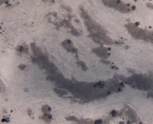
The following picture is cut from the 4 meter resolution jpg on Dan Bollingers site. The green border shows the edge of the original 1 meter resolution image. Note how small and indistinct The 'Ring' structure is at this resolution. I have included extra terrain to the north and to the east of The 'Ring'. The 4 meter resolution makes indepth analysis of these areas impossible.
Here's a little speculation...
If The 'Ring' is the Tribal Council set, then the Tribal Camp sites must be within a couple of kilometers of that location. To keep the conditions for each tribe as equal as possible they would be located in areas of similar vegetation, etc. and each would probably be located an equal distance from the Tribal Council set. The area for competitions would also be centrally located.
There are two areas where trees are clustered that are approximately the same distance from The 'Ring' Tribal Council set. I have drawn a blue box and a red box to highlight these as likely areas for tribal camps. The yellow area in the middle would be a likely area for competitions.
I think that it is more than a little suspicious that Dan Bollinger has not released 1 meter resolution photos of these areas (at least I haven't been able to find them). I do not think that it's simply a case of the satellite imaging company taking a a low resolution wide area image followed by two separate high res images. I strongly suspect that there are things to be seen in these areas and I would really love to get my paws on some good images!


Table of contents
- RE: Is There More to the Satellite Photo?,SurvivorBlows, 01:20 AM, 09-03-01
- Dan Bollinger's Response...,IceCat, 03:47 AM, 09-03-01
- Parsing,AyatollahKhomeini, 12:42 PM, 09-04-01
Messages in this discussion
"RE: Is There More to the Satellite Photo?"
Posted by SurvivorBlows on 09-03-01 at 01:20 AM
Ice, I understand what you're saying here, but I don't think there is any conspiracy here -- I just think that either that was all the images they had or that there was nothing else in the remaining images.Keep up the great work!

"Dan Bollinger's Response..."
Posted by IceCat on 09-03-01 at 03:47 AM
Dan Bollinger was nice enough to email me a copy of the 1 meter resolution ring photo in the same format as he received it from Space Imaging.The image does not go much further north or east than the original images that he posted. I'll post the upper right corner of the image so you can see the small strip of extra image that is available. Note the lower left corner - it shows the rectangular 'camera scaffold' structure. The upper right corner is the border of the satellite image:
I guess it's a bit of a shot in the dark when you take your best guess in terms of latitude and longitude and have a satellite take a picture. My hat's off to Dan for getting the ring in the frame of the satellite image.

"Parsing"
Posted by AyatollahKhomeini on 09-04-01 at 12:42 PM
I think parsing the picture requires extra work from SpaceImaging. I would expect that Dan Bollinger requested that certain areas be parsed and expanded, and those are the areas that SpaceImaging did. I don't know what their plans are for the rest of the image...